Weather event update – 11am, 16 February 2026

By Moana Ellis, Local Democracy Reporting
Thousands of homes are without power and several major highways are closed across Whanganui, Rangitīkei, Manawatū and Ruapehu districts, but the heavy rain is beginning to ease.
A state of emergency is in place for the Manawatū-Whanganui region, with three of its districts (Manawatū, Rangitīkei and Tararua) declaring local emergencies.
Emergency management teams across the districts were continuing to monitor conditions on Monday as significant disruption remains.
An Emergency Operations Centre in Whanganui was stood up overnight and remains staffed.
Controller Catherine Dutton said teams would continue monitoring and responding throughout the day.
Red Cross and emergency management staff made contact on Sunday evening with residents in areas including Kauangāroa and Mangamāhu to ensure they were prepared for possible evacuation.
“While the Whanganui River was not expected to flood, predictions for the eastern areas of our district were more concerning,” Dutton said.
“Fortunately, we are now seeing the rain easing and river levels dropping.”
Dutton said there were multiple trees down across the district and contractors had been removing those throughout the night.
“We’re providing updates on social media, on our website, via our Antenno app and through releases to local media,” Dutton said.
Evacuations and power outages
A total of 37 people have been evacuated from properties at Herbertville on the East Coast and at Saddle Road and River Road in Ashhurst due to rising rivers.
More than 17,000 homes across the region remain without power, including 7500 in Whanganui.
Residents are being directed to check their local lines company websites for outage updates.
Heavy rain warnings remain in place until 3pm Monday, according to MetService, which is expected to review watches and warnings later this morning.
Most waterways across the region appear to have peaked.
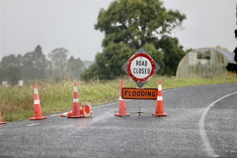
Road closures widespread
As of 7.15am, several major highways were closed:
- SH1 between Hunterville and Taihape – closed
- SH1 just north of Foxton – closed
- SH3 from SH4 to Whangaehu – closed
- SH54 from SH1 to Cheltenham – closed
- SH3 Pūtiki to Whangaehu – closed
- Napier–Taihape Road – closed
SH3 at Turakina and Awahuri are now open, while SH56 is likely to close as conditions deteriorate.
Residents are urged to check routes via the New Zealand Transport Agency Journey Planner before travelling.
Authorities warn flooding may become more apparent as daylight reveals damage and as water moves down from the ranges into catchment areas.
Thirty-five schools, mainly in Manawatū, Rangitīkei and Tararua districts, are closed. Families are advised to contact schools directly for further information.
Residents of Taihape, Mangaweka, Hunterville and Rātana are being asked to conserve water until further notice.

Public safety advice
Emergency officials are urging residents to avoid non-essential travel.
Drivers are reminded that speed limits are not a target and that unreported hazards may still be present.
Residents are advised:
- If in doubt, get out – pre-emptive evacuation is safer than waiting for conditions to worsen.
- Never walk, swim, play or drive in flood water.
- If power is lost, unplug major appliances to prevent surge damage and use torches instead of candles.
- Those reliant on electrically powered medical equipment should call 111 or go to the nearest medical centre if safe to do so.
- Use radios to stay informed if power or mobile data is limited.
If in immediate danger, call 111. Emergency calls will connect via other available networks, even if a phone displays “No Service”.
Weather updates are available via MetService, and road closure information via NZTA and local councils.
Awa FM – Te Reo Irirangi o Whanganui
For more of our people, our stories, our way, click News or follow us on Facebook.